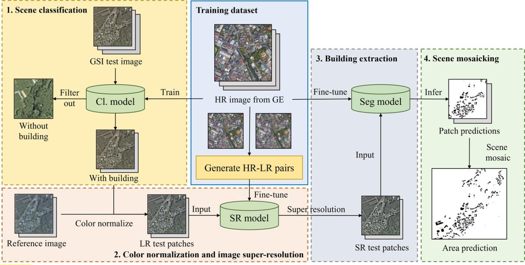
本研究はオープンソースの衛星画像から建物フットプリントマップを取得できることを示しています。具体的には、本研究では、比較的低解像度(0.6m以上)のオープンソースデータセット(国土地理院の衛星画像)を入力とし、超解像(SR)とインスタンスセグメンテーション技術(Mask R-CNN with MPViT backbone)に基づく大規模建物抽出フレームワークが提案されました。本モデルは兵庫県(19,187 km2)の3,301,488棟(32.46 km2)の建物のうち1,726,006棟(29.12 km2)を抽出しており、この結果はベースラインモデル(ResNeXt 101)と比べて棟数、フットプリント面積についてそれぞれ3.0%、5.0%増加したものになっています。F値については野外、農村、郊外、都市部でそれぞれ0.71、0.70、0.81、0.67が達成されました。これらの数値はカラー調整と画像の超解像化がオープンソースの衛星画像の視覚的品質と建物の抽出精度を向上させることを示しています。
This research proposes a large-scale building extraction framework based on super-resolution (SR) and instance segmentation (Mask R-CNN with MPViT backbone) using a relatively lower-resolution (>0.6 m) open-sourced dataset (satellite images from GSI). We took Hyogo Prefecture, Japan (19,187 km2) as a test area and extracted 1,726,006 (29.12 km2) of the 3,301,488 buildings (32.46 km2), where the number of buildings and footprint area increased by 3.0 % and 5.0 % respectively. The result indicated that the color normalization and image super-resolution could improve the visual quality of open-source satellite images and contribute to building extraction accuracy and achieved F1 scores of 0.71, 0.70, 0.81, and 0.67 for non-built-up, rural, suburban, and urban areas, respectively. This research demonstrates the potential of acquiring acceptable building footprint maps from open-source satellite images.
【論文情報】
Chen, S., Ogawa, Y., Zhao, C., & Sekimoto, Y. (2023). Large-scale individual building extraction from open-source satellite imagery via super-resolution-based instance segmentation approach. ISPRS Journal of Photogrammetry and Remote Sensing, 195, 129-152. https://doi.org/10.1016/j.isprsjprs.2022.11.006