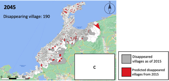
本研究では、2015年の日本全国の世帯推計データとエージェントベースのマイクロシミュレーションによる世帯推移モデルを構築し、南砺市の空き家分布・北陸地方の消滅集落の分布予測に利用しました。世帯推計データは、家族類型 、住居種類 、世帯構成員の住所、年齢、性別で構成されています。2015年の推定世帯データの結果は、都道府県レベルの5歳階級別人口(R2=0.871、MAPE=6.135%)、家族類型別世帯数(R2=1.000、MAPE=1.375%)で高い精度を持つことが確認されました。世帯推移モデルについては, 富山県と静岡県における1980~2010年のシミュレーションで精度検証が行われ、市町村別・性別・5歳階級別での人口(R2 = 0.986; MAPE = 1.584%), 市町村別・家族類型16分類別での世帯数(R2 = 0.878; MAPE = 19.39%)で高い精度が確認されました。
The estimated household data for all cities of Japan in 2015 and an agent-based microsimulation household transition model were constructed in this research, and subsequently used to forecast the distribution of vacant houses in Nanto City and disappearing villages in Hokuriku region. Estimated household data comprised of family type, house type, address, age, and gender of household members. The result of estimated household data in 2015 was verified to have high accuracy in prefectural-level population by five-year age group (R2 = 0.871; MAPE = 6.135%), and household volume by family type (R2 = 1.000; MAPE = 1.375%). Simulation results in Toyama and Shizuoka Prefectures from 1980 to 2010 indicated high model accuracy in municipal-level population by five-year age group (R2 = 0.986; MAPE = 1.584%), and household volume by family type (R2 = 0.878; MAPE = 19.39%).
【論文情報】
Kento Kajiwara, Jue Ma, Toshikazu Seto, Yoshihide Sekimoto, Yoshiki Ogawa, Hiroshi Omata, Development of current estimated household data and agent-based simulation of the future population distribution of households in Japan, Computers, Environment and Urban Systems, Elsevier, Volume 98, December. 2022, 101873, DOI (Impact factor in 2021: 6.454)