【論文要旨】
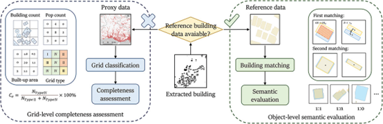
深層学習に基づく建物抽出手法は、多岐にわたる分野で広く応用されています。しかし、従来の評価手法が手作業で作成されたグランドトゥルースサンプルに依存していることや、発展途上国における総合的な参照建物データの不足により、大規模な抽出結果の評価は依然として困難です。これらの課題を解決するために、本研究は大規模フットプリント抽出を評価するための2レベルのフレームワークを提案しました。まず、グローバルなオープンソースの人口と土地利用データを代理データとして利用し、参照データが不足している地域のグリッドレベルでの完全性を評価します。次に、抽出されたフットプリントを参照建物とマッチングさせるために、改良された双方向エリアオーバーラッピング法を導入し、調査地域の総合的な評価を可能にしました。兵庫県と沼津市でテストを行った結果、単一の代理指標を用いた場合と比較して、グリッド分類精度が2.6%向上し、完全性の相関が0.53増加しました。さらに、最適化されたマッチング手法は、マルチスケールマッチングにおいて高い効率性と頑健性を持ち、99%という卓越したセマンティックマッチング精度を達成しました。したがって、提案手法は、大規模なフットプリント抽出結果を効果的に評価し、実際の建物とのセマンティック関係を解釈することができ、参照建物データセットの有無に関係なく、グローバルに適用可能です。
Deep learning-based building extraction methods have widespread applications in diverse fields. However, the evaluation of large-scale extraction results remains challenging, due to traditional evaluation metrics relying on manually created ground-truth samples and the lack of comprehensive reference-building data for developing countries. To address these problems, we proposed a two-level framework for evaluating large-scale footprint extraction. First, we utilized global open-source population and land use data as the proxy data, to assess grid-level completeness for the areas with insufficient reference data. Second, we introduced an improved two-way area-overlapping method to match the extracted footprints with the reference buildings, thereby enabling a comprehensive evaluation of the study region. Tested in Hyogo Prefecture and Numazu City, Japan, the results demonstrated a 2.6-% improvement in grid classification accuracy and an increase of 0.53 in the completeness correlation, compared with the results obtained using a single proxy indicator. Moreover, the optimized matching method achieved an outstanding semantic matching accuracy of 99%, with high efficiency and robustness in multi-scale matching. Therefore, the proposed approach can effectively evaluate large-scale footprint extraction results and interpret their semantic relationship with actual buildings, applicable globally regardless of the availability of reference building datasets.
提案した2レベル建物抽出評価フレームワークのフローチャート:グリッドレベルの完全性評価とオブジェクトレベルの意味評価を含みます。
Flowchart of the proposed two-level building extraction evaluation framework, including grid-level completeness assessment and object-level semantic evaluation.
【論文情報】
Chen, S., Ogawa, Y., Zhao, C., & Sekimoto, Y. (2024). Enhanced large-scale building extraction evaluation: developing a two-level framework using proxy data and building matching. European Journal of Remote Sensing, 57(1), 2374844.
https://doi.org/10.1080/22797254.2024.2374844