
The article “RDD2022: A multi-national image dataset for automatic road damage detection”, by Project Assistant Professor Deeksha Arya and colleagues, has been published in “Geoscience Data Journal”, an international journal by Royal Meteorological Society (2023 Impact Factor: 3.3).
The article introduces the Road Damage Dataset 2022 (RDD2022) to advance the field of automated road damage detection. Launched as part of the Crowdsensing-based Road Damage Detection Challenge (CRDDC’2022), with contributions from the challenge winners, RDD2022 includes 47,420 images from six countries (Figure 1) – Japan, India, the Czech Republic, Norway, the United States, and China – covering over 55,000 instances of road damage (Cracks and Potholes). Sample images are shown in Figure 2.
Since its release, RDD2022 has been downloaded over 14,000 times, demonstrating its widespread adoption and relevance to the research community.
RDD2022 has also been utilized for Global Road Damage Detection Challenges, including CRDDC’2022 and the latest Optimized Road Damage Detection Challenge, ORDDC’2024 competition. In CRDDC’2022, the top model achieved an impressive F1-score of 76.9% across all six countries. In ORDDC’2024, with a participation of 42 teams from 19 countries, the winning team proposed two models based on RDD2022: one optimized for accuracy, achieving a peak F1-score of 86.18% at an inference speed of 136.41 milliseconds per image, and another optimized for speed, delivering 26.8 milliseconds per image with an F1-score of 79.27%. These outcomes highlight the dataset’s potential to drive significant advancements in road damage detection, providing practical solutions for real-world road maintenance.
Beyond road damage detection, RDD2022 serves as a benchmark for researchers in computer vision, geoscience, and machine learning, offering a resource for evaluating algorithms in image-based applications like classification and object detection.
Check out the article to discover how this research drives real-world solutions.
https://doi.org/10.1002/gdj3.260
論文「RDD2022: A multi-national image dataset for automatic road damage detection」 は、Deeksha Arya特任助教らによって執筆され、Royal Meteorological Society社の国際的な学術誌「Geoscience Data Journal」に掲載されました(2023年インパクトファクター:3.3)。
この記事では、道路の自動損傷検出分野の進展を目指して、道路損傷データセット2022(RDD2022)を紹介しています。RDD2022は、Crowdsensingベースの道路損傷検出チャレンジ(CRDDC’2022)の一環として発表され、チャレンジの受賞者によって貢献されました。データセットには、6カ国(日本、インド、チェコ共和国、ノルウェー、アメリカ合衆国、中国)からの47,420枚の画像が含まれており、55,000件以上の道路損傷(亀裂と穴)をカバーしています(図1)。サンプル画像は図2に示されています。
公開以来、RDD2022は14,000回以上ダウンロードされており、研究コミュニティにおける広範な採用と重要性を示しています。
RDD2022は、CRDDC’2022をはじめ、最新の最適化道路損傷検出チャレンジ(ORDDC’2024)など、世界規模の道路損傷検出チャレンジの開催にも活用されています。CRDDC’2022では、トップモデルが6カ国全てでF1スコア76.9%という優れた結果を達成しました。ORDDC’2024では、19カ国から42チームが参加し、優勝チームはRDD2022を基にした2つのモデルを提案しました。一つは精度重視で、F1スコア86.18%を達成し、推論速度は1画像あたり136.41ミリ秒、もう一つは速度重視で、F1スコア79.27%を達成し、推論速度は1画像あたり26.8ミリ秒でした。これらの成果は、道路損傷検出における重要な進展を促進するRDD2022の可能性を示し、実世界での道路メンテナンスの実用的な解決策を提供しています。
道路損傷検出を超えて、RDD2022はコンピュータビジョン、地球科学、機械学習の研究者にとって、分類や物体検出などの画像ベースのアプリケーションでアルゴリズムを評価するための基準として役立っています。
この研究がどのように実世界の課題解決に貢献しているのか、記事でご確認ください。
https://doi.org/10.1002/gdj3.260
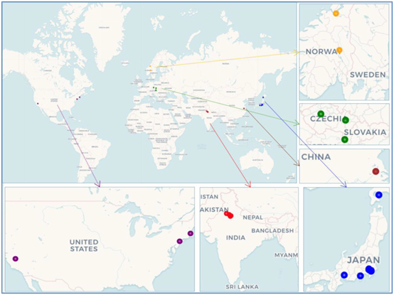
Figure 1: Geographical distribution of major data collection sites from countries included in RDD2022
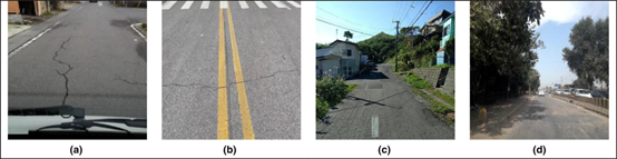
Figure 2: Sample images for road damage categories considered in the data. (a) Longitudinal Crack (D00), (b) Transverse Crack (D10), (c) Alligator Crack (D20), (d) Pothole (D40).
Citation:
Arya, Deeksha, Hiroya Maeda, Sanjay Kumar Ghosh, Durga Toshniwal, and Yoshihide Sekimoto. “RDD2022: A multi‐national image dataset for automatic road damage detection.” Geoscience Data Journal 11, no. 4 (2024): 846-862. https://doi.org/10.1002/gdj3.260
This article has been awarded the Open Data Badge for making publicly available the digitally-shareable data necessary to reproduce the reported results. Data is available at
https://doi.org/10.6084/m9.figshare.21431547.v1