本研究では、異なる主体が計測する様々なタイプの建物計測データを、効果的に活用していくために、信頼性のある三次元建物モデル(本研究では国土交通省PLATEAUデータ)に幾何形状的にマッチングする手法を開発し、WebAPIとしても実装しました。
具体的には、二次元の建物ポリゴンの計測データの場合は、既存の研究を拡張する形で二次元ポリゴン同士の重複判定を再定義し、沼津市全体の88,525個の建物フットプリント(住宅地図)について適用した所、90.6%のポリゴンに対しマッチングでき、8.2%に対しリジェクト(マッチングなし)と判定し、1.2%がグレーで目視判断が必要という区分を示すことに成功しました。マッチング実行時間は沼津市全体に対し104秒と短時間で行えるようになるとともに、目視を1.2%に抑えた事で、実用的にも確認が必要な作業時間は大幅に短縮できるようになりました。
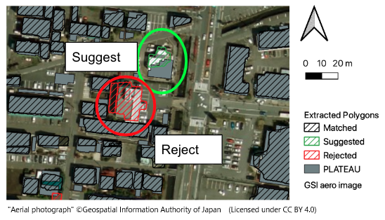
さらに本マッチング手法を活用し、航空写真について超解像度化・建物抽出処理・抽出した建物輪郭に対するマッチングを行いました。マッチングの前処理として航空写真から抽出される建物数はPLATEAU建物数の70.9%に留まりましたが、抽出した建物については93.6%のポリゴンに対しPLATEAU建物IDのマッチングが行え、実用上の見通しをつけることができました。
また、三次元の点群データはPLATEAUのLOD1, 2などの三次元形状に結びつけ、46個の建物を対象にテクスチャ付き三次元都市モデルを自動作成することに成功しました。二次元データに比べると相対的に処理時間はかなり増えてしまうものの、建物表面に対する点群が存在する割合として定義した網羅率については、道路沿いを計測したMMSでは概ね網羅率20%以上、空から計測したLPでは網羅率40%以上となり、計測手法に応じたカバー状況を明確にすることができました。
Currently, the Ministry of Land, Infrastructure, Transport, and Tourism (Japan) is in the process of developing an open 3D city model known as PLATEAU. Abundant measurement data related to buildings, including maps produced by private companies and mobile mapping system point clouds, have been collected to enhance the value of the 3D city model. To achieve this, it is necessary to identify the buildings for which measurement data is available. In this study, we propose and evaluate an efficient matching method for various building measurement data, primarily using geometric properties. In Numazu city, PLATEAU IDs were assigned to 88,525 Zenrin buildings as part of a private map. The results indicate that 90.6% of the polygons were matched. For aerial images, 93.6% of the extracted buildings matched the PLATEAU buildings, although only 70.9% of the PLATEAU data was extracted from the images. Using the level of detail 1 and 2 models, 46 textured building files were created from the mobile mapping system point cloud. In addition, the cover ratio for the laser profiling point cloud was mostly greater than 40%, which was higher than that of the mobile mapping system.
【論文情報】
Ogawa Y, Sato G, Sekimoto Y (2024) Geometric-based approach for linking various building measurement data to a 3D city model. PLoS ONE 19(1): e0296445.
https://doi.org/10.1371/journal.pone.0296445
図:航空写真から抽出したポリゴンのマッチング・サジェスト結果
Fig. Results of the matching and suggestion process for 2D footprints extracted from aerial images.
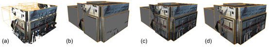
図:LOD2建物に対する複数のテクスチャマッピングアルゴリズム適用結果
Fig. Texture mapping results for an LOD2 building with different mapping settings.